
Buying on High Rock: what nobody tells you
High Rock Lake Water Level, Drawdown & Dock Rules: What Buyers Need to Know
Where the High Rock Lake water level sits today, why it is allowed to drop every winter, who actually controls the shoreline, and what the dock in the listing photo is worth once you read the permit.
Start with the paperwork
Who runs High Rock Lake, and why that matters to you
High Rock Lake is not a natural lake. It is a reservoir on the Yadkin River, completed in 1927 and the uppermost of the four lakes in the Yadkin hydroelectric project. The High Rock Lake dam holds back 15,180 acres of water with roughly 360 miles of shoreline across Davidson and Rowan counties, which makes it one of the largest reservoirs in North Carolina. How deep is High Rock Lake? About 59 feet at the dam and about 16 feet on average, so most of the lake is far shallower than the dam end.
So who owns High Rock Lake? The dam and the project land along the shoreline are owned and operated by Cube Hydro Carolinas (part of Eagle Creek Renewable Energy) under a FERC license through 2055 (Yadkin Project P-2197). Alcoa sold the project in 2017.
Why that matters: the shoreline is a licensed hydro project, not ordinary county land. Your dock, your trees along the water and your seawall need the operator’s permit under its Shoreline Management Plan; county permits for the house, septic and well are separate. The lake level is set by the license, not by the weather alone. The county will still send the tax bill.
The level
How the water level works (and why it can be low every winter)
The quickest answer to “what is the High Rock Lake water level today” is the operator’s own gauge page, which posts hourly readings and drawdown notices: cubecarolinas.com/lake-levels. Nothing on this page replaces it.
The longer answer is the license. Full pond is 655 feet. The license lets Cube run the lake up to 4 feet below full from April through October and up to 10 feet below full from November through March, plus exceptions for minimum downstream flows, drought (the Low Inflow Protocol) and emergency or maintenance work. If you are asking why High Rock Lake is so low in January, the first answer is that it is allowed to be.
Recent years show how far a High Rock Lake drawdown can go. In February 2025, dam repairs held the lake 8.5 to 9 feet below full until about March 10. This fall, a maintenance drawdown runs October 1 through November 30, 2026: about 4 feet down on September 30, stepping to roughly 8 feet below full, held through at least November 20, then refilling late November into December depending on rain. The basin was already in D1 drought in late September 2026, so treat the refill dates as a forecast, not a promise.
One trap: the lake has two elevation datums. 655.0 feet on the lake’s own Yadkin datum is the same water as 623.9 feet USGS. If two sites disagree by about 31 feet, they are counting from different zero points.
Questions about a notice or a specific reading go to the operator, not to us: the official lake-level page or 704-422-5555.
Where the water goes
What drawdown does to a dock
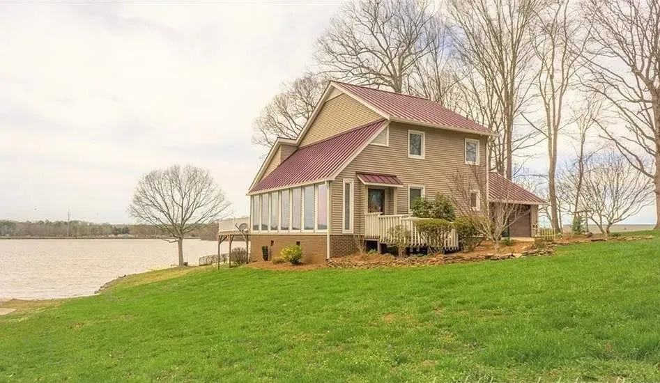
A pier permit on High Rock requires 6 feet of water within 75 feet of the shore, measured at full pool. “Full pool” is the phrase to underline. Our inference, not a rule from the plan: if a slip only clears that minimum by a foot or two at 655, an 8 to 10 foot winter drawdown can leave it sitting on mud. A dock that floats in a listing photo taken in June is not evidence of anything in January.
Ask for the depth at the end of the dock at low water, not on the day you tour. Then ask where the lot sits, because three lots with the same frontage can be three different boating experiences.
Open water
In practice, expect the most depth to work with and the most exposure to wind and wake. Drawdown tends to move the waterline rather than strand the dock, but confirm the low-water depth anyway.
Protected cove
Calmer water and easier docking. Depth depends on how far into the cove the lot sits, so the low-water question matters most here.
Back of a cove
Typically the shallowest position and, by the same inference, the most likely to lose usable depth in a drawdown. You cannot simply dig it out: dredging and sediment removal inside the project boundary require an activity permit from the operator.
The permit
Dock permits: the rules, the fees, and what transfers when you buy
Every private pier on High Rock Lake sits inside the Yadkin Project Shoreline Management Plan, administered by Cube Hydro Carolinas under the FERC license. The High Rock Lake Association (HRLA) is a voluntary lake group; it cannot issue a High Rock Lake dock permit or help you get one. The rules, forms and fee schedule live at cubecarolinas.com/shoreline-management.
What Appendix E of the plan requires for a new private pier:
- A lot with at least 200 feet of shoreline, or 50 feet for lots developed before May 1, 1987. Adjoining lots under a common deed count as one lot.
- 6 feet of water within 75 feet of shore at full pool.
- A cove at least 100 feet wide, with the pier taking up no more than 25% of that width.
- A pier no longer than 75 feet and no larger than 1,100 square feet.
- A house under roof before a construction permit is issued.
- In subdivisions, lots are pier-eligible only if the developer completed the operator’s environmental assessment and subdivision access approval. Community docks are permitted separately.
Fees effective January 1, 2025: eligibility determination $175; pier construction permit $250 plus $100 a year; permit transfer $175. Repair, modification and vegetation permits carry their own fees; check the current schedule for those and for penalties on unpermitted structures.
When you buy a house that already has a dock, the permit transfers only if the pier is compliant, in good repair, and the fees are current. The seller or their agent contacts Cube before the sale for a site visit. A non-compliant pier gets a written repair list first. The buyer signs a new permit at closing, and any past-due fees have to be cleared.
“There is a dock” is not the same as “there is a transferable permit.” In October 2023 the lake association reported that many previously approved pier permits had been rescinded under the operator’s reading of the plan. Ask for the current permit number, in writing, before your due-diligence period ends. None of this is legal advice; the plan and the current fee schedule govern, so confirm anything that matters with the operator in writing.
The shoreline
Trees, buffers, seawalls
The operator’s shoreline rules apply inside the FERC project boundary. Where that line sits on a given parcel is a plat and deed question, not a guess. Confirm anything you plan to do inside that line with the operator in writing first; none of this is legal advice.
Trees and buffers
Any vegetation removal inside the project boundary needs a written activity permit. Lots in subdivisions platted on or after July 1, 1999 keep a 100-foot forested setback; a septic field or well may sit inside it. Limited view-corridor trimming can be permitted. Nothing comes out within 30 feet of a drainageway.
Seawalls and riprap
Shoreline stabilization is by activity permit: an assessment first, then the permit, and engineering may be required.
Dredging and fill
Excavation, dredging and fill inside the project boundary are permit-only. Not a Saturday project with a rented excavator, however tempting the back of the cove looks in November.
Boat ramps
Private boat ramps are prohibited except as permitted. If a listing shows one, ask for the permit along with everything else.
The rest of the file
Flood zones, septic, water quality
Three things that have nothing to do with the dock and everything to do with the house.
Flood zone
Look the address up at NC FRIS or the FEMA Map Service Center for the zone, base flood elevation and panel. Base flood elevations are in NAVD88, not the lake datum, so do not compare them to 655. Get the zone in writing and ask your insurer what it means for the policy.
Septic and well
Much of the lake area is not on municipal utilities. Permit history and lot evaluations come from the county: Davidson County Environmental Health, 336-242-2300, or Rowan County Environmental Health, 704-216-8525.
Water quality
NC DEQ lists High Rock Lake as impaired for chlorophyll-a, turbidity and pH, and notes that algal blooms may produce harmful toxins; nutrient rules were still being drafted when we wrote this. Designated swim areas are at Buddle Creek (2882 Holloway Church Rd, Lexington) and Pebble Beach (287 Flat Swamp Lake Rd, Denton). Check current advisories before anyone gets in.
Due diligence
The 8 things to get in writing before your due-diligence period ends
- Eligibility determination or current permit number. For a bare lot, the eligibility determination is the whole ballgame. For a house with a dock, the permit number and its standing with Cube.
- Depth at the dock at low water. Measured, not estimated.
- The plat with the project boundary. It shows where the operator’s rules start and where your yard ends.
- The access right and whether it conveys. Deeded, shared or community access: who holds it, who maintains it, what it costs, and whether it transfers with the sale.
- Permit fees current. Past-due fees have to be cleared before a transfer.
- Flood zone letter. Zone, base flood elevation and panel for the exact address.
- Septic and well permit history. From the county environmental health office, not the listing remarks.
- HOA or community-dock documents, if any. Rules, dues and who actually holds the community dock permit.
None of this is legal advice, and none of it should come from a listing description. Have your agent confirm each item with the listing side while a bad answer still leaves you room to walk. Buying a lot to build on? Start with High Rock Lake lots and land for sale, where eligibility is the first question. On a tighter budget, High Rock Lake homes under $400,000 tend to be near-lake rather than waterfront, and the dock question may not apply at all.
Quick answers
Quick answers
What is the water level of High Rock Lake today?
Check the operator’s official gauge at cubecarolinas.com/lake-levels, which posts hourly readings and drawdown notices. Full pond is 655 feet on the lake’s datum (623.9 feet USGS). Under its federal license the lake may run up to 4 feet below full from April through October and up to 10 feet below full from November through March, with drought and maintenance exceptions.
Why is High Rock Lake so low?
Because the license allows it. Cube Hydro Carolinas may draw the lake down up to 10 feet below full pond in winter and up to 4 feet in summer, and can go further for drought, downstream flow requirements or maintenance. In fall 2026 a scheduled maintenance drawdown is taking the lake to about 8 feet below full through at least November 20, with refill expected late November into December.
How deep is High Rock Lake?
High Rock Lake is about 59 feet deep at the dam and roughly 16 feet deep on average, so most of the lake is far shallower than the dam end. Depth at any specific dock depends on where the lot sits, and it changes with drawdown, so ask for the depth at low water rather than at full pond.
Who owns High Rock Lake?
The dam and the project land along the shoreline are owned and operated by Cube Hydro Carolinas (part of Eagle Creek Renewable Energy) under a FERC license through 2055 (Yadkin Project P-2197). The lake was built by an Alcoa subsidiary and completed in 1927; Alcoa sold the project in 2017.
Do I need a permit for a dock on High Rock Lake?
Yes. Any private pier on High Rock Lake needs a permit from Cube Hydro Carolinas under the Yadkin Project Shoreline Management Plan. Lots generally need 200 feet of shoreline (50 feet if developed before May 1, 1987), 6 feet of water within 75 feet of shore at full pool, and a house under roof before a construction permit is issued. The lake association cannot issue permits.
Does a dock permit transfer when I buy a house on High Rock Lake?
Only if the pier is compliant, in good repair and the permit fees are current. The seller or their agent contacts Cube Hydro Carolinas before the sale for a site visit, and non-compliant piers get a written repair list first. The buyer signs a new permit at closing and pays a $175 transfer fee. An existing dock is not proof of a transferable permit.
Talk to Mantle
Want someone to read the permit before you fall for the dock photo?
We work High Rock Lake from Lexington, and we have seen enough listing photos taken at full pond to know which questions to ask. Send us the address and we will tell you what to request from the listing side before your due-diligence clock starts.
Where to look next
Communities and counties around the lake
The lake sits across two counties with different tax rates, different health departments and different sides of the water. Each page below covers one of them.
Southmont
The lake community on NC 8 on the Davidson side, with its own public boating access area.
Denton
Davidson County, at the Flat Swamp Creek end of the lake, home of the Pebble Beach swim area.
Salisbury
The city base for the Rowan County side of the lake and the Bringle Ferry Road corridor.
Davidson County
The north and east shore: Southmont, Lexington, Linwood, Denton and the Abbotts Creek arm.
Rowan County
The south and west shore: Salisbury, Spencer, Tamarac and the Dutch Second Creek side.